User-Defined Alerts

The User-Defined Alerts tab allows users to create, edit, and delete alerts based on specific geozones and flight parameters. These alerts help monitor for UAS activity that meets defined conditions such as altitude, location, speed, or aircraft type. Users can also view reports of all flights that have triggered these alerts for tracking, investigation, or compliance purposes.

eplasp.io_(High Res) (19) 1
Alert Table Overview

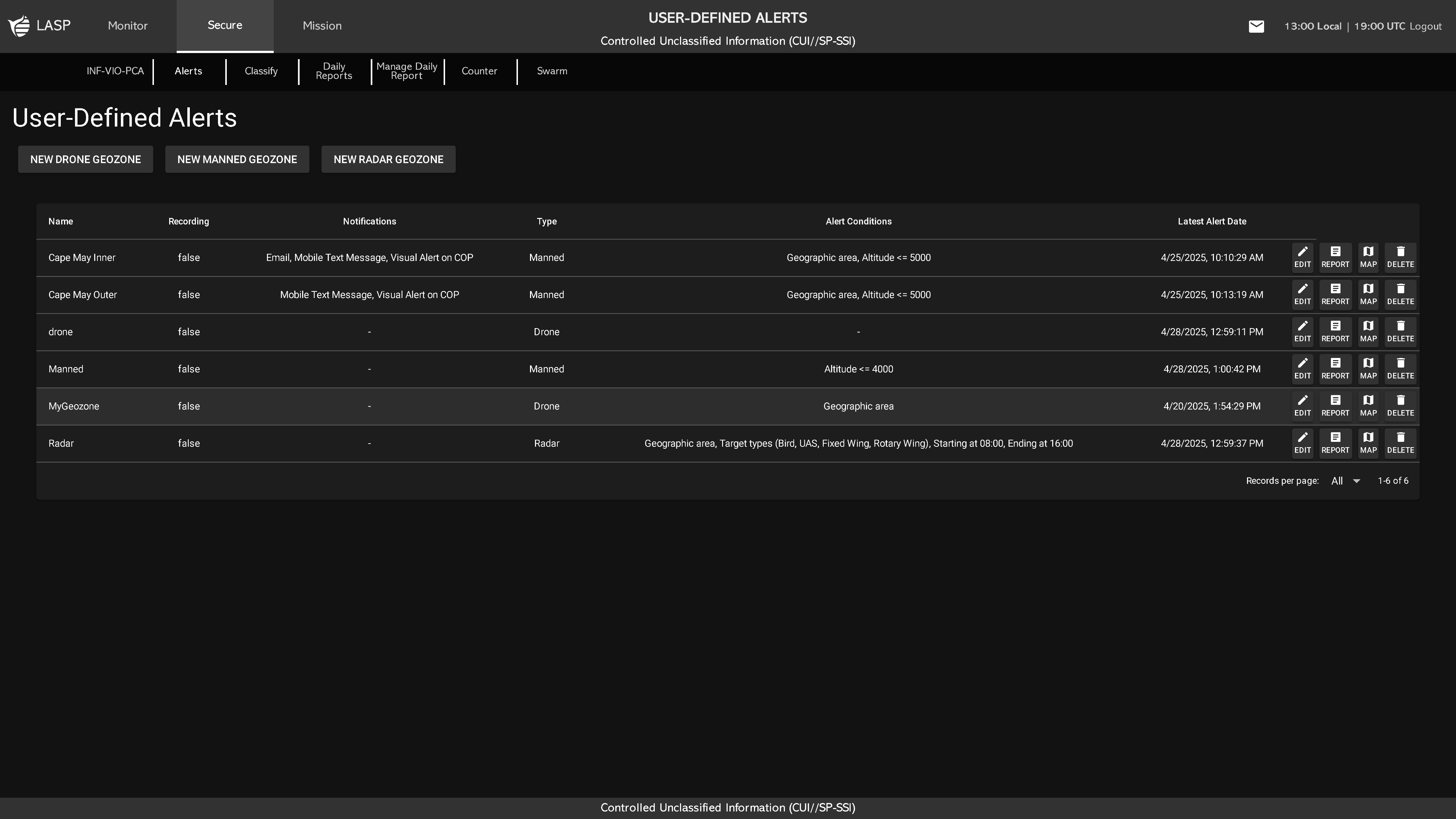
The main table displays all configured alerts, with each row showing:

  • Name – Name assigned to the alert
  • Recording – Indicates whether camera recording is enabled (true/false)
  • Notifications – Methods enabled for receiving alerts (Email, Mobile Text, Visual, Audible)
  • Type – Type of alert: Drone, Manned, or Radar
  • Alert Conditions – Summary of criteria used to trigger the alert
  • Latest Alert Date – Timestamp of the most recent alert event
  • Edit – Opens the alert configuration popup
  • Report – Displays all flights that triggered the alert
  • Map – Shows the geographic area associated with the alert
  • Delete – Prompts a confirmation popup (DELETE or BACK)
Creating a Geozone Alert

To create a new alert, click one of the following buttons:

  • NEW UAS GEOZONE
  • NEW MANNED GEOZONE
  • NEW RADAR GEOZONE
eplasp.io_(High Res) (20) eplasp.io_(High Res) (21) eplasp.io_(High Res) (22)

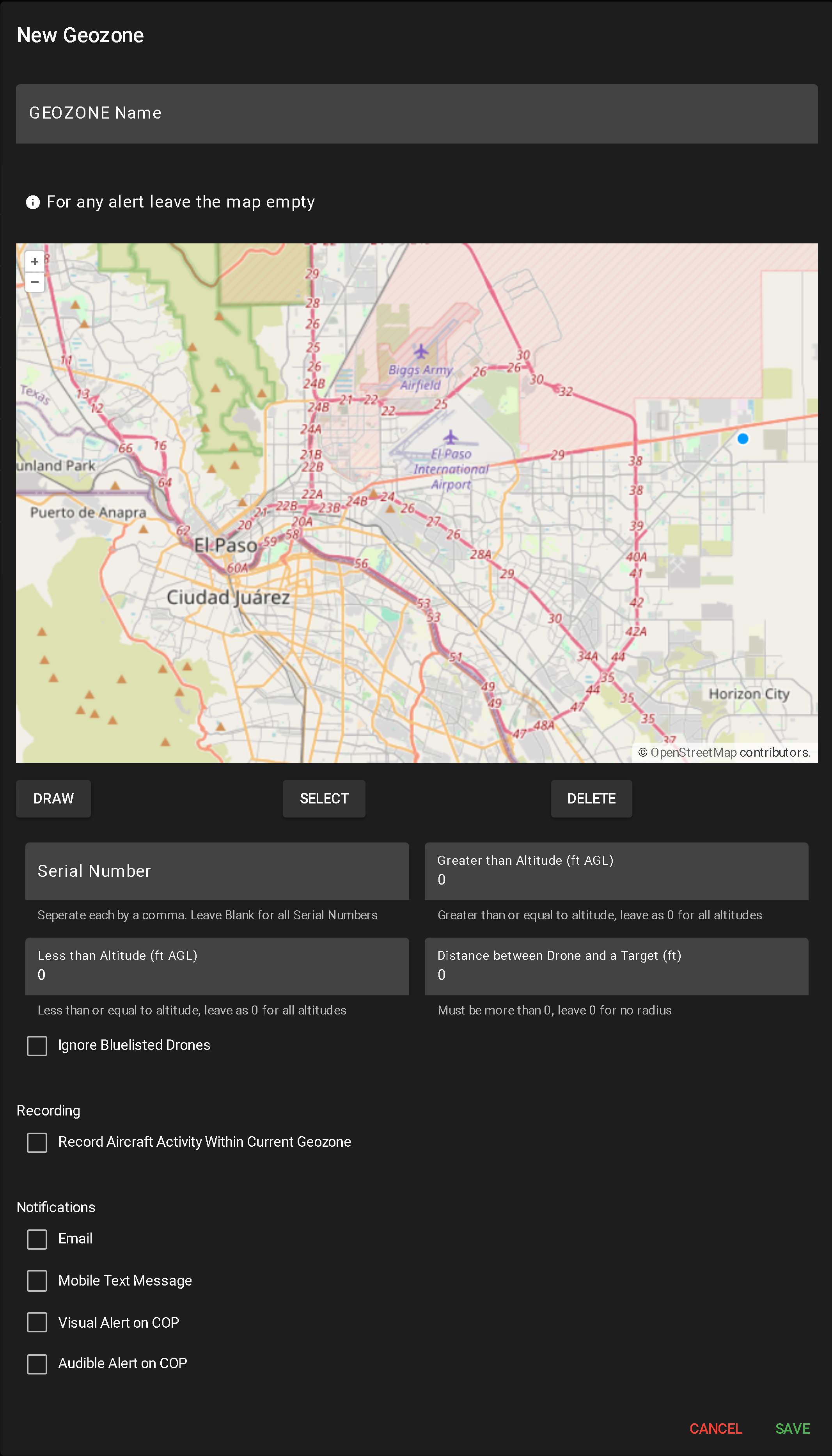
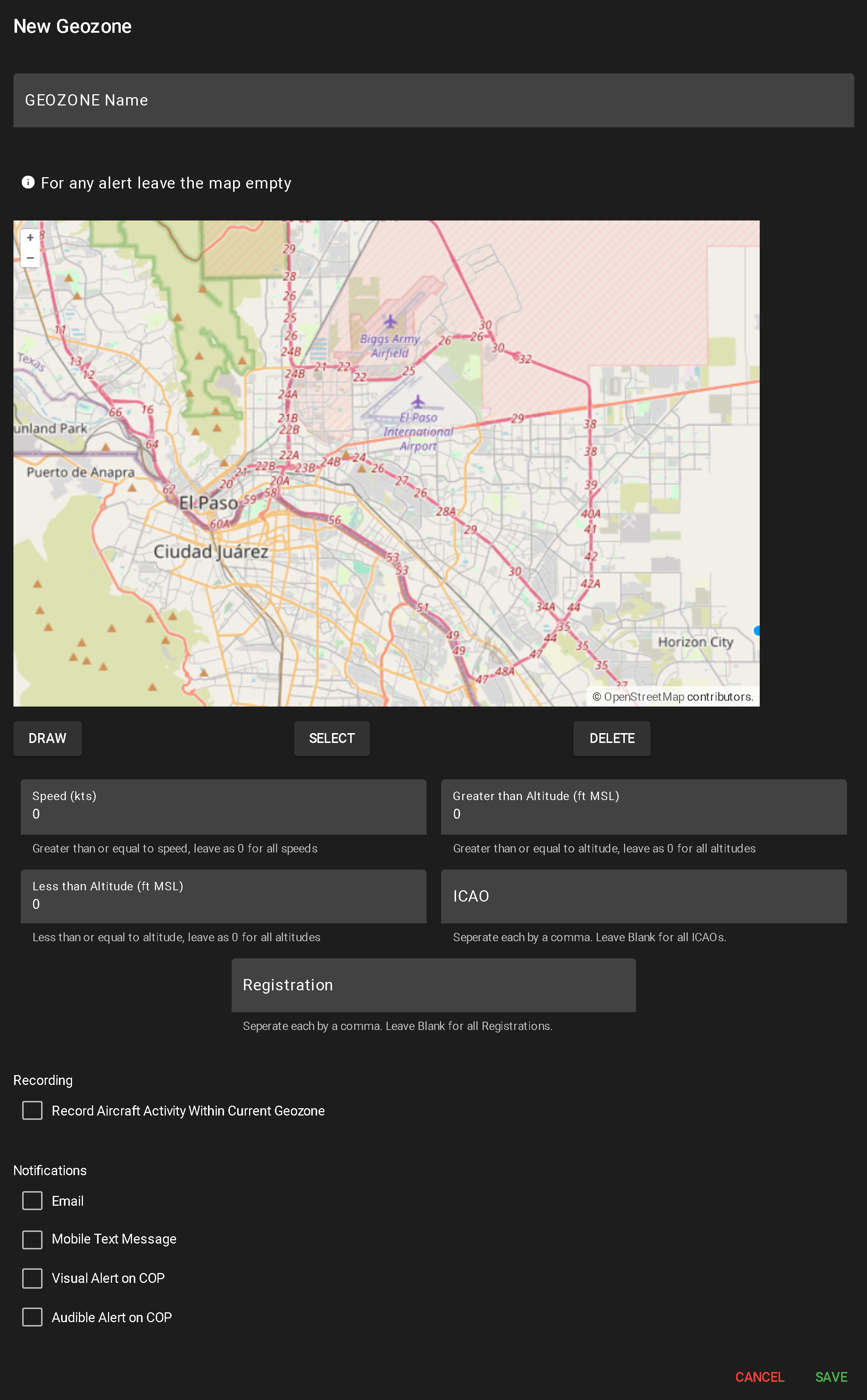
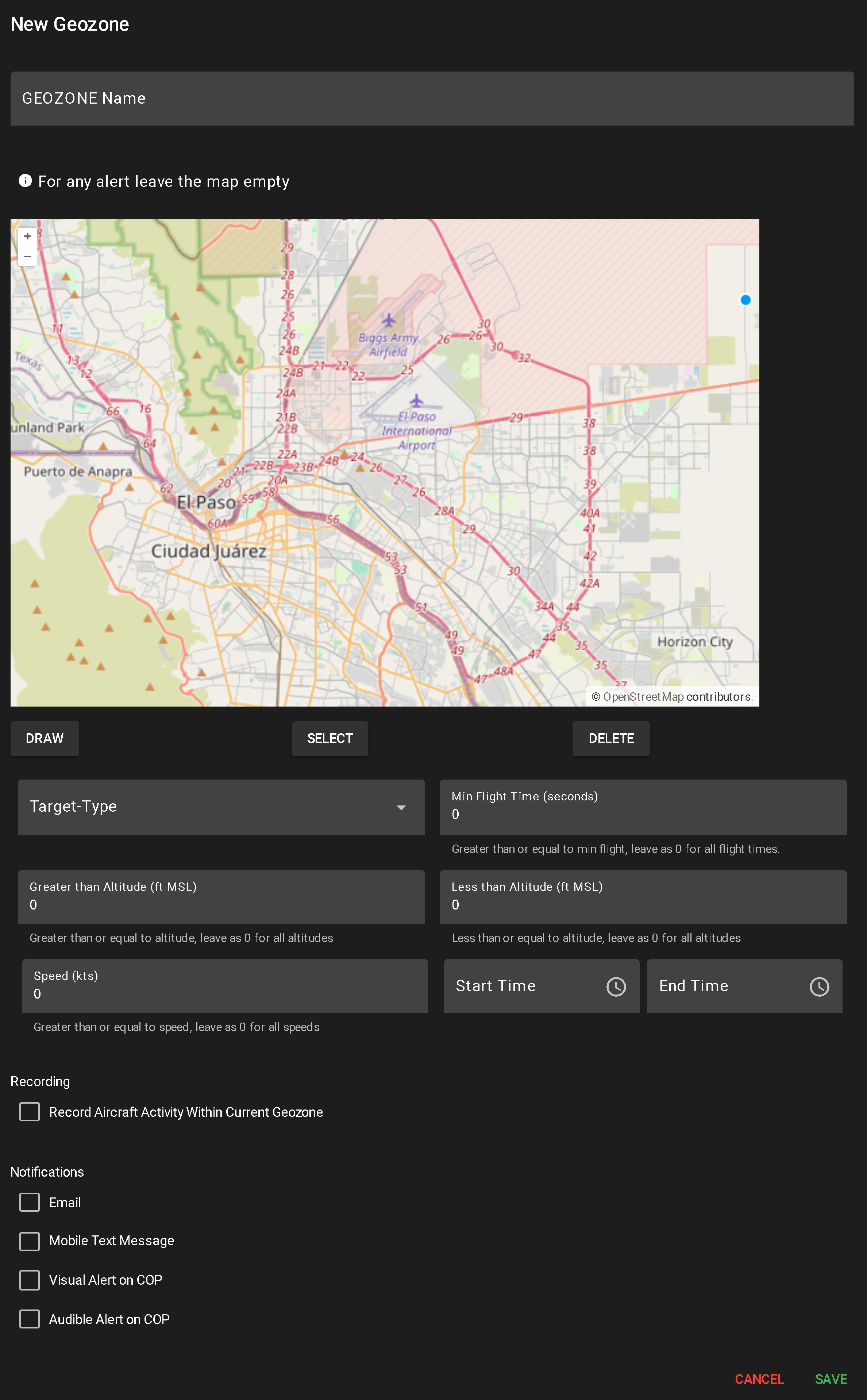
This opens a configuration popup for alert setup:

  1. Enter Geozone Name
    • A required field used to identify the alert in the system.
  2. Draw Geographic Area (Optional)
    • Use the DRAW tool to define the monitoring area:
      • Click to create each segment
      • Double-click or click the origin to complete the shape (minimum two segments required)
      • Multiple shapes can be drawn
      • Leaving the map blank applies the alert system-wide
    • To delete a shape, click SELECT, highlight the shape, and click DELETE.
  3. Toggle Camera Recording
    • Check or uncheck “Record Aircraft Activity Within Current Geozone” to enable/disable video capture when the alert triggers.
  4. Configure Notification Methods
    • Select any combination of the following to determine how alerts are delivered:
      • Email
      • Mobile Text Message
      • Visual Alert on COP
      • Audible Alert on COP
  5. Input Alert Conditions

Viewing Alert Reports

When a user clicks the Report button for a user-defined alert, a popup table appears displaying all flights that have triggered that alert. The layout and functionality are similar to Flight History (see more about Flight History).

eplasp.io_(High Res) (23) 1

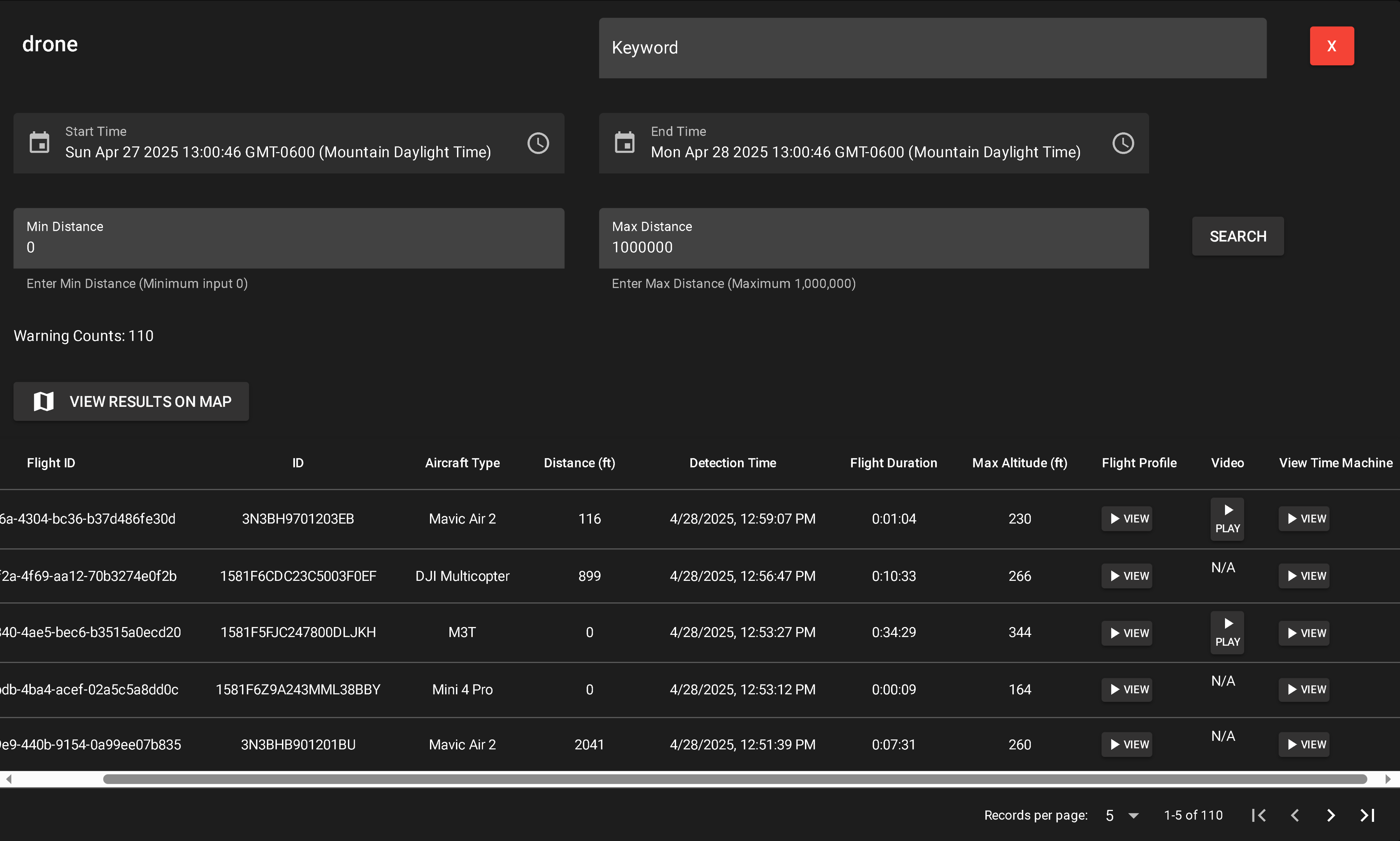
Report Table Columns

  • Flight ID – Internal log ID
  • ID – Serial or tail number
  • Aircraft Type – Drone, mlat, etc
  • Distance (ft) – Distance between drone and pilot (Drone alerts only)
  • Detection Time – When the aircraft was detected
  • Flight Duration – Duration of the flight
  • Max Altitude (ft) – Highest point reached
  • Flight Profile – Opens a flight profile view (see more about Flight Profile)
  • Video – Appears if a recording is available; opens video playback
  • View in Time Machine – Loads flight in COP Time Machine view (see more about Time Machine)
Filtering & Search Options
  • Keyword Search – Dynamically filters by any column
  • Start Time / End Time – Date/time range for search
  • Min Distance (ft) – Drone alerts only; minimum pilot distance
  • Max Distance (ft) – Drone alerts only; maximum pilot distance
  • Search Button – Applies time and distance filters
  • Warning Count – Displays number of matched results